
Garmin BlueChart g3 Vision Seekarten
Premium-Seekarten für kompatible Garmin Kartenplotter
Garmin BlueChart g3 Vision bietet die detaillierte Kartografie von BlueChart g3 und ergänzt sie um zusätzliche Premium-Funktionen für die Navigation und Törnplanung.
Je nach Kartenregion stehen unter anderem hochaufgelöste Reliefdarstellung, Satellitenbilder und 3D-Ansichten zur Verfügung. Auch detaillierte Hafen- und Marinaansichten unterstützen die Orientierung in unbekannten Revieren.
Bei LEPPER marine finden Sie Garmin BlueChart g3 Vision Seekarten für unterschiedliche Fahrtgebiete und Abdeckungsgrößen.
Die passende Kartenabdeckung auswählen
Unsere BlueChart g3 Vision Karten sind nach Kartengebiet und Abdeckungsgröße gegliedert. Wählen Sie zunächst die passende Abdeckung und anschließend das gewünschte Fahrtgebiet.
Wichtig: BlueChart g3 Vision ist eine vorherige Garmin Kartengeneration. Prüfen Sie deshalb vor dem Kauf die Kompatibilität Ihres Garmin Kartenplotters anhand der offiziellen Garmin-Kompatibilitätsübersicht.
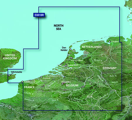
VEU018R-Benelux Offshore & Inland
Details: Informationen Produktcode VEU018R Name The Netherlands Typ Garmin BlueChart g3 Vision Abdeckung Continental coverage: from Spiekeroog, Germany to Calais, France, including The Netherlands and Belgium coast entirely. Great Britain coverage: from Whitstable to Folkestone. Kompatibilität siehe Reiter Kompatible Plotter Kartenupdate Hier klicken
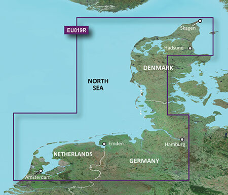
VEU019R-Alborg - Amsterdam
Details: Informationen Produktcode VEU019R Name Alborg-Amsterdam Typ Garmin BlueChart g3 Vision Abdeckung Includes detailed coverage from Ålborg Bugt to Amsterdam, The Netherlands, including Limfjorden, Hamburg, Bremen and Emden. Kompatibilität siehe Reiter Kompatible Plotter Kartenupdate Hier klicken

VEU021R-Denmark East-Sweden Southeast
Details: Informationen Produktcode VEU021R Name Denmark East & Sweden Southeast Typ Garmin BlueChart g3 Vision Abdeckung Swedish coast: from Göteborg to Karlskrona, including Malmö and Trelleborg, as well as lakes Mjörn and Bolmen. Danish, German, and Polish coasts: Lemvig, Denmark to Szczecin, Poland, including Limfjorden, Skagen, Den., Copenhagen, Den., Stralsund, Ger., and the islands of Sjælland, Fyn, Møn, Falster, Lolland, Langeland and Fehmarn. Kompatibilität siehe Reiter Kompatible Plotter Kartenupdate Hier klicken

VEU041R-Oslo-Skagerak-Haugesund
Details: Informationen Produktcode VEU041R Name Oslo-Skagerak-Haugesund Typ Garmin BlueChart g3 Vision Abdeckung Detailed coverage of the Norwegian and Swedish coasts from Skånevik, NO to Göteborg, SE including Boknafjorden, Oslofjorden, the Skagerrak, Lake Mjøsa, Lake Bandak, Lake Kviteseidvatnet, Lake Flåvatn, Lake Norsjø, Lake Heddalsvatnet, the Telemark Canal, the upper Kattegat and the island of Laeso. Kompatibilität siehe Reiter Kompatible Plotter Kartenupdate Hier klicken
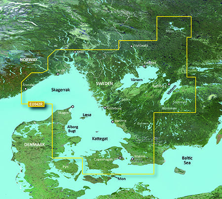
VEU042R-Oslo - Trelleborg
Details: Informationen Produktcode VEU042R Name Oslo-Trelleborg Typ Garmin BlueChart g3 Vision Abdeckung Detailed coverage of the Norwegian and Swedish coasts from Grimstad, NO to Ystad, SE including Oslo, NO and Malmö, SE. Also includes coverage of the Danish coast from Hirtshals through Copenhagen, the Skagerrak, the Kattegat, the Orosund, the island of Laeso, and Lakes Fryken, Vänern, Vättern, Mjörn, Sommen, Nommen, and Bolmen in Sweden. Kompatibilität siehe Reiter Kompatible Plotter Kartenupdate Hier klicken

VEU043R-Iceland to Orkney
Hoch entwickelte Kartenplotter arbeiten am besten mit hochwertigem Kartenmaterial. Deshalb hat Garmin seine BlueChart-g3Technologie jetzt noch einmal verbessert und BlueChart® g3 Vision auf den Markt gebracht. BlueChart® g3 Vision ist mit den neuen Kartenplottern von Garmin kompatibel: 420/420s/520/520s/525/525S/4008/4012 Die neue g3-Version bietet: Unter Berücksichtigung von Tiefgang und lichter Höhe berechnet AutoGuidance Routenvorschläge. Es kann mit der Funktion "3D Fisheye"ein 3D Bild des Meeresgrundes dargestellt werden. Detaillierte Satellitenbilder sind als Basemap hinterlegt. Topografische Merkmale, Küstenstraßen, Hafenpläne und Stadtgebiete werden noch detaillierter beschrieben und dargestellt. Zusätzlich sind Luftaufnahmen für viele Häfen abrufbar Bei der weiterentwickelten BlueChart® g3 Vision-Marinekartografie können Details auf der Karte in der 3D-Perspektive angezeigt werden, ähnlich der Perspektive des Steuermanns Das System verfügt über eine erweiterte IALA-Navigationshilfensymbolik. Eine optimierte Verwaltung der Kartenkacheln und bessere Einbindung der Kartengrafiken ermöglicht einfacheres Verschieben, Scrollen und Zoomen Intensive Displayfarben und Schattierungen ermöglichen ein einfacheres Ablesen Angaben zu dieser Seekarte: Bezeichnung BlueChart g3 Vision Seekartenmodul REGULAR VEU043R Karteninhalt Includes detailed coverage of all of Iceland including the cities of Reykjavik and Akureyri. Also includes detailed coverage of the Faeroe Islands including Stromo, Ostero, Sydero and Bordo Islands.

VEU046R-Sweden, Southeast
Details: Informationen Produktcode VEU046R Name Sweden, South-East Typ Garmin BlueChart g3 Vision Abdeckung Detailed coverage of the south and east coasts of Sweden from Helsingborg to Gävle including Trelleborg, Nykoping, Stockholm, Norrtalje, Karlsborg as well as Copenhagen, DK. Coverage of lakes include Lakes Vänern, Vättern, Sommen, Siljan, Fryken and Helgasjön; as well as coverage of the lower Dalälven from Gysinge to Söderfors and of the Strömsholms Kanal to Smedjebacken. Island coverage includes Bornholm DK, Oland and Gotland SE, and Åland, FI. Finnish coverage also extends to Turku and Hanko. Kompatibilität siehe Reiter Kompatible Plotter Kartenupdate Hier klicken

VEU047R-Gulf of Bothnia
Details: Informationen Produktcode VEU047R Name Gulf of Bothnia-Kalix-Grisslehamn Typ Garmin BlueChart g3 Vision Abdeckung Detailed coverage of the Gulf of Bothnia from Gavle, SE through Pori, FI including Oulu and Vaasa, FI. Swedish coverage includes Luleå Skärgård, and Lakes Tjeggelvas, Hornavan, Siljan, Aisjaur, Fluka, Uddjaur, Storavan, Revsundssjön and Storsjön as well as coverage of the lower Dalälven from Gysinge to Söderfors. Coverage of the islands of Hailuoto, Vallgrund, and Åland is also included. Kompatibilität siehe Reiter Kompatible Plotter Kartenupdate Hier klicken

VEU050R-Gulfs of Finland & Riga
Details: Informationen Produktcode VEU050R Name Aland-Vyborg Typ Garmin BlueChart g3 Vision Abdeckung Detailed coverage of the Gulf of Finland from Åland to Vyborg, Finland. Also includes detailed coverage of the cities of Turku, Helsinki, and Kotka in Finland and Tallinn and Kohtla-Jarve in Estonia. Kompatibilität siehe Reiter Kompatible Plotter Kartenupdate Hier klicken

VEU051R-Lista - Sognefjorden
Details: Informationen Produktcode VEU051R Name Lista-Sognefjorden Typ Garmin BlueChart g3 Vision Abdeckung Detailed coverage of the Norway coast from Farsund to Sognefjorden, including the Shetland Islands. Includes detailed coverage of Bergen, Haugesund and Stavanger. Kompatibilität siehe Reiter Kompatible Plotter Kartenupdate Hier klicken

VEU052R-Sognefjorden - Svefjorden
Details: Informationen Produktcode VEU052R Name Sognefjorden-Svefjorden Typ Garmin BlueChart g3 Vision Abdeckung Includes detailed coverage of the Norway coast from Sognefjorden to Afjord. Also includes detailed coverage of Alesund, Kristiansund, Hitra and Trondheim. Kompatibilität siehe Reiter Kompatible Plotter Kartenupdate Hier klicken

VEU053R-Trondheim-Tromsø
Details: Informationen Produktcode VEU053R Name Trondheim-Tromsø Typ Garmin BlueChart g3 Vision Abdeckung Detailed coverage of the Norway coast from Trondheim to Tromsø. Includes detailed coverage for Sandnessjoen, Bodo, Vaeroy, Langoya, Narvik, and Vestfjorden, as well as lakes Tjeggelvas, Hornavan, Uddjaur, Aisjaur, Fluka, Storavan, Revsundssjön and Storsjön. Kompatibilität siehe Reiter Kompatible Plotter Kartenupdate Hier klicken

VEU054R-Vestfjd-Svalbard-Varanger
Details: Informationen Produktcode VEU054R Name Vestfjd-Svalbard-Varanger Typ Garmin BlueChart g3 Vision Abdeckung Detailed coverage of the northern Norway coast from Vestfjorden to Vadso including Tromsø and Narvik. Also includes coverage for Svalbard and approaches. Kompatibilität siehe Reiter Kompatible Plotter

VEU055R-Finnish Lakes
Details: Informationen Produktcode VEU055R Name Finnish Lakes Typ Garmin BlueChart g2 Vision Abdeckung Detailed coverage of inland Finnish lakes including Inarijarvi, Miekojarvi, Simojarvi, and Kiantajarvi. Also includes detailed coverage of Oulujarvi, Pielinen, Saimaa, Paijanne, Nasijarvi, Lohjanjärvi, and others. Kompatibilität siehe Reiter Kompatible Plotter Kartenupdate Hier klicken

VEU061R-France Inland Waters
Hoch entwickelte Kartenplotter arbeiten am besten mit hochwertigem Kartenmaterial. Deshalb hat Garmin seine BlueChart-g3Technologie jetzt noch einmal verbessert und BlueChart® g3 Vision auf den Markt gebracht. BlueChart® g3 Vision ist mit den neuen Kartenplottern von Garmin kompatibel: 420/420s/520/520s/525/525S/4008/4012 Die neue g3-Version bietet: Unter Berücksichtigung von Tiefgang und lichter Höhe berechnet AutoGuidance Routenvorschläge. Es kann mit der Funktion "3D Fisheye"ein 3D Bild des Meeresgrundes dargestellt werden. Detaillierte Satellitenbilder sind als Basemap hinterlegt. Topografische Merkmale, Küstenstraßen, Hafenpläne und Stadtgebiete werden noch detaillierter beschrieben und dargestellt. Zusätzlich sind Luftaufnahmen für viele Häfen abrufbar Bei der weiterentwickelten BlueChart® g3 Vision-Marinekartografie können Details auf der Karte in der 3D-Perspektive angezeigt werden, ähnlich der Perspektive des Steuermanns Das System verfügt über eine erweiterte IALA-Navigationshilfensymbolik. Eine optimierte Verwaltung der Kartenkacheln und bessere Einbindung der Kartengrafiken ermöglicht einfacheres Verschieben, Scrollen und Zoomen Intensive Displayfarben und Schattierungen ermöglichen ein einfacheres Ablesen Angaben zu dieser Seekarte: Bezeichnung BlueChart g3 Vision Seekartenmodul REGULAR VEU061R Karteninhalt Detailed coverage of coastal and interior France including the coast from Marseille to St. Cyprien, Bayonne to St-Nazaire and La Havre to Dunkirk. Coverage of interior waterways include the Adour, Garonne, Charente, Loire, Seine and Rhone River systems. The Sevre-Nantaise, Somme, Meuse, Moselle, and Saone Rivers, the Rhine from Basel, CH to Karlsruhe, DE; Lake Leman (Geneva), Lake Neuchatel, Lake Biel, Lake Morat, the Canal du Midi, the Canal du Centre and the Rhine-Rhone Canal are also covered.

VEU065R-Baltic Sea, East Coast
Details: Informationen Produktcode VEU505S Name Baltic Sea, East Coast Typ Garmin BlueChart g3 Vision Abdeckung Coverage of the coasts of Germany, Poland, Russia, Lithuania, Latvia and Estonia from Rügen, DE to Narva-Jõesuu, EE. Detailed coverage includes the Szczecin Lagoon, Bornholm, the Vistula Lagoon, Kaliningrad, Gotland, the Gulf of Riga, Saaremaa, Hiiumaa, Lake Peipus, and the Mazurian and other Polish lakes including Lake Jeziorak, Lake Łańskie and Lake Śniardwy. Kompatibilität siehe Reiter Kompatible Plotter Kartenupdate Hier klicken

VEU452S-Adriatic Sea, North Coast
Details: Informationen Produktcode VEU452S Name Adriatic Sea, North Coast Typ Garmin BlueChart g3 Vision Abdeckung Detailed coverage of the Adriatic Sea coast from Trani to Monfalcone, IT southeast to Dubrovnik, HR. Includes detailed coverage of Lago Maggiore, Lago di Como, Lago d'Iseo, Lago di Garda and the Po River from the Adriatic to the Ticino River confluence. Kompatibilität siehe Reiter Kompatible Plotter Kartenupdate Hier klicken

VEU456S-English Channel, Central-East
Details: Informationen Produktcode VEU456S Name English Channel, Central-East Typ Garmin BlueChart g3 Vision Abdeckung Detailed coverage of the British coast from Weymouth to Ramsgate including Southampton, Portsmouth, Eastbourne, and Dover; French coast coverage from Saint-Brieuc to Dunkerque, including Saint-Malo, Saint-Vaast-la-Hougue, Grandcamp-Maisy, Le Havre, Dieppe, Le Tréport , and the Seine River to Rouen. Coverage features the Isle of Portland, the Solent, the Isle of Wight, and the Channel Islands of France. Kompatibilität siehe Reiter Kompatible Plotter Kartenupdate Hier klicken

VEU457S-Bretagne
Details: Informationen Produktcode VEU457S Name Bretagne Typ Garmin BlueChart g3 Vision Abdeckung From Saint-Vaast-la-Hougue to Le Croisic and Belle-Ile, including Cherbourg, the Channel Islands, Saint-Malo, Brest, and Lorient. Kompatibilität siehe Reiter Kompatible Plotter Kartenupdate Hier klicken

VEU458S-Göteborg-Fyn
Details: Informationen Produktcode VEU458S Name Göteborg to Fyn Typ Garmin BlueChart g3 Vision Abdeckung Swedish coast: from Göteborg to Malmö, including lakes Mjörn and Bolmen. Danish coast: from Hirtshals through Fyn, including Århus; also includes Copenhagen and Limfjorden. Kompatibilität siehe Reiter Kompatible Plotter Kartenupdate Hier klicken

VEU461S-Thames Estuary
Details: Informationen Produktcode VEU461S Name Thames Estuary Typ Garmin BlueChart g3 Vision Abdeckung Great Yarmouth to Folkestone, including Thames Estuary and River to Teddington Lock. Kompatibilität siehe Reiter Kompatible Plotter Kartenupdate Hier klicken

VEU463S-Bristol Channel and England S/W
Details: Informationen Produktcode VEU463S Name Bristol Channel and England S/W Typ Garmin BlueChart g3 Vision Abdeckung Aberporth, Wales south to the Scilly Islands and east to include Portland, South England. Includes the whole Bristol Channel. Kompatibilität siehe Reiter Kompatible Plotter Kartenupdate Hier klicken

VEU464S-Penmarch to Les Sables d'Olonne
Details: Informationen Produktcode VEU464S Name Penmarch to Les Sables d'Olonne Typ Garmin BlueChart g3 Vision Abdeckung Detailed coverage from Guilvinec to Les Sables D'Olonne including St. Nazaire, the Loire to Nantes, Belle Ile, Ile de Groix, and Ile d'Yeu. Kompatibilität siehe Reiter Kompatible Plotter Kartenupdate Hier klicken

VEU465S-La Baule to San Sebastian
Details: Informationen Produktcode VEU465S Name La Baule to San Sebastian Typ Garmin BlueChart g3 Vision Abdeckung Detailed coverage from Bermeo, Spain to St. Nazaire, France including La Rochelle, Cap Ferret, and La Gironde. Kompatibilität siehe Reiter Kompatible Plotter Kartenupdate Hier klicken
Garmin BlueChart g3 Vision Seekarten
Mit Garmin BlueChart g3 Vision erhalten Sie eine besonders umfangreiche elektronische Seekartenlösung für kompatible Garmin Kartenplotter.
BlueChart g3 Vision basiert auf der BlueChart-g3-Kartografie und ergänzt diese um zusätzliche Premium-Funktionen. Dazu gehören je nach Region und Kartenprodukt unter anderem hochaufgelöste Reliefdarstellung, Satellitenbilder, 3D-Ansichten sowie detaillierte Ansichten von Häfen und Marinas.
Damit eignet sich BlueChart g3 Vision nicht nur für die klassische Navigation, sondern auch für die detaillierte Vorbereitung von Törns und die Orientierung in unbekannten Revieren.
Was ist der Unterschied zwischen BlueChart g3 und g3 Vision?
BlueChart g3 Vision enthält die Funktionen von BlueChart g3 und erweitert sie um zusätzliche Premium-Kartendaten und Darstellungen.
| Funktion | BlueChart g3 | BlueChart g3 Vision |
|---|---|---|
| Detaillierte elektronische Seekarte | ✓ | ✓ |
| Tiefenlinien und Tiefeninformationen | ✓ | ✓ |
| Tiefenbereichsschattierung | ✓ | ✓ |
| Navigationshilfen | ✓ | ✓ |
| Hafen- und Marinainformationen | ✓ | ✓ |
| Auto Guidance auf kompatiblen Plottern | ✓ | ✓ |
| Hochauflösende Reliefdarstellung | – | ✓ |
| Satellitenbilder | – | ✓ |
| 3D-Ansichten | – | ✓ |
| Erweiterte Hafen-/Marinaansichten | – | ✓ |
Die tatsächlich verfügbaren Funktionen können abhängig von Kartengebiet und kompatiblem Kartenplotter variieren. Garmin beschreibt BlueChart g3 Vision als Premium-Kartografie mit zusätzlichen Funktionen gegenüber BlueChart g3.
BlueChart g3 Vision mit Relief Shading
Eine der besonderen Funktionen von BlueChart g3 Vision ist die hochauflösende Reliefdarstellung.
Dabei werden Farben und Schattierungen kombiniert, um die Struktur des Meeresbodens anschaulicher darzustellen als mit reinen Tiefenlinien. Die Darstellung kann insbesondere für Angler und Skipper interessant sein, die sich für Unterwasserstrukturen, Riffe, Kanten und andere Bodenformationen interessieren.
Die Verfügbarkeit und Abdeckung dieser Funktion kann je nach Kartenregion unterschiedlich sein.
BlueChart g3 Vision mit Satellitenbildern
Je nach Kartenregion bietet BlueChart g3 Vision zusätzlich hochaufgelöste Satellitenbilder.
Diese können beispielsweise bei der Orientierung entlang der Küste oder bei der Annäherung an unbekannte Häfen hilfreich sein. Durch die zusätzliche visuelle Information lässt sich die Umgebung auf dem Kartenplotter besonders anschaulich darstellen.
3D-Ansichten mit BlueChart g3 Vision
BlueChart g3 Vision bietet auf kompatiblen Garmin Kartenplottern zusätzliche 3D-Darstellungen.
Dazu gehören unter anderem perspektivische Ansichten wie MarinerEye und FishEye. Sie können eine zusätzliche Perspektive auf die Umgebung und die Gewässerstruktur bieten und damit die klassische Kartenansicht ergänzen.
Detaillierte Hafen- und Marinaansichten
Bei der Ansteuerung eines unbekannten Hafens können zusätzliche Detailinformationen besonders hilfreich sein.
BlueChart g3 Vision bietet für unterstützte Gebiete detaillierte Ansichten von Häfen und Marinas. Dadurch können beispielsweise Hafenanlagen und die nähere Umgebung übersichtlicher dargestellt werden.
BlueChart g3 Vision nach Kartenabdeckung
Die BlueChart-g3-Vision-Karten sind für unterschiedliche geografische Regionen und Abdeckungsgrößen erhältlich.
Garmin verwendet hierfür unter anderem die Kennzeichnungen:
-
S – Small
-
R – Regular
-
L – Large
-
X – X-Large
Die Kennzeichnung ist Bestandteil der Garmin-Produktnummer und beschreibt die Größe der Kartenabdeckung.
Welche Größe für Ihren Törn sinnvoll ist, hängt vom gewünschten Fahrtgebiet ab.
BlueChart g3 Vision für Europa
Für europäische Fahrtgebiete stehen verschiedene BlueChart-g3-Vision-Karten zur Verfügung.
Dazu gehören je nach Kartenregion unter anderem Bereiche der Nordsee, Ostsee, britischen Inseln, französischen und spanischen Atlantikküste sowie des Mittelmeers.
Die genaue Abdeckung unterscheidet sich von Karte zu Karte. Deshalb sollten Sie vor dem Kauf immer die auf der jeweiligen Produktseite angegebene Abdeckung prüfen.
BlueChart g3 Vision für Nordsee und Ostsee
Für Skipper in Deutschland sind insbesondere BlueChart g3 Vision Karten für Nordsee und Ostsee interessant.
Je nach Kartenregion können Küstenbereiche Deutschlands und angrenzender Länder abgedeckt sein. Die passende Karte sollte anhand des konkreten Törngebiets ausgewählt werden.
BlueChart g3 Vision für das Mittelmeer
Auch für das Mittelmeer stehen unterschiedliche BlueChart-g3-Vision-Karten zur Verfügung.
Je nach Region können beispielsweise die Küsten von Spanien, Frankreich, Italien, Griechenland oder weitere Mittelmeerregionen abgedeckt werden.
Achten Sie bei der Auswahl auf die exakte Kartenabdeckung des jeweiligen Produkts.
Welche BlueChart g3 Vision Karte ist die richtige?
Bei der Auswahl sollten Sie insbesondere drei Punkte berücksichtigen:
1. Fahrtgebiet
Welche Küsten und Gewässer möchten Sie befahren?
2. Kartenabdeckung
Benötigen Sie eine regionale Abdeckung oder möchten Sie ein größeres Fahrtgebiet mit einer Karte abdecken?
3. Kartenplotter-Kompatibilität
Unterstützt Ihr Garmin Kartenplotter BlueChart g3 Vision und die gewünschten Funktionen?
Kompatibilität prüfen
BlueChart g3 Vision gehört zur vorherigen Garmin Kartengeneration. Garmin empfiehlt deshalb, vor dem Kauf die Kompatibilität des konkreten Kartenplotters zu prüfen.
[Garmin Kartenplotter-Kompatibilität prüfen]
BlueChart g3 Vision bei LEPPER marine
Bei LEPPER marine finden Sie Garmin BlueChart g3 Vision Seekarten für zahlreiche Fahrtgebiete und unterschiedliche Kartenabdeckungen.
Als Fachhändler für Marine-Elektronik unterstützen wir Sie bei der Auswahl der passenden elektronischen Seekarte für Ihren Garmin Kartenplotter.
Wenn Sie unsicher sind, welche BlueChart g3 Vision Karte, Kartenabdeckung oder Kartenregion für Ihren Törn geeignet ist, sprechen Sie uns gerne an.